Call us at +306949885983

Crete Under Water: Extraordinary Rainfall Hits the Island as Xyloskalo Records More Than 400 mm in Two Days

Crete is facing one of the most severe rainfall events of recent years, with extraordinary amounts of water falling across the island and the mountain area of Xyloskalo in Chania emerging as one of the main centers of the storm.
For a place famous around the world for its sunshine, beaches and long summers, Crete has experienced a dramatically different face of nature over the past few days.
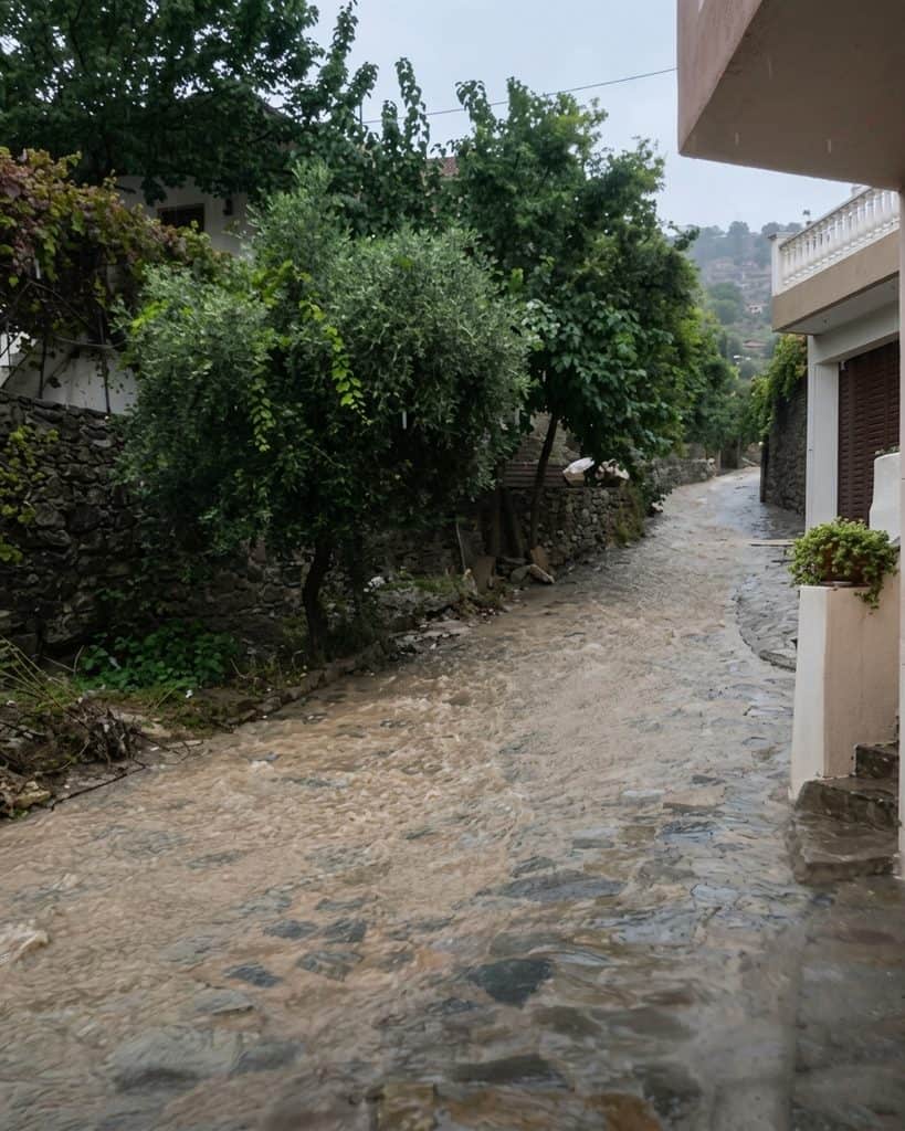
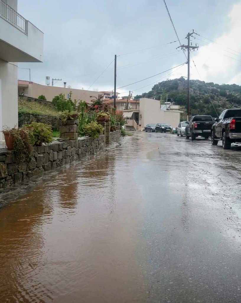
From Friday, October 2, through Saturday, October 3, powerful rain and thunderstorms have battered large parts of the island. Roads have flooded, rivers and streams have overflowed, landslides have disrupted transportation and emergency crews have been working across several regions.
But the numbers recorded by the automatic weather-station network of the National Observatory of Athens / meteo.gr are perhaps the clearest way to understand just how exceptional the rainfall has been.
At Xyloskalo in the Chania region, the rainfall total climbed above 400 millimeters during the event.
The figure has been updated several times as the rain continued. An initial meteo.gr report published Saturday morning recorded 440 mm, followed by a later update showing 318 mm through 10:20 a.m. A further update available Saturday evening reported 420 mm at Xyloskalo.
Whatever the final verified total becomes, the scale is extraordinary.
And it is not simply a number on a weather station.
It represents hundreds of liters of water falling on every square meter of ground.
What Does 420 Millimeters of Rain Actually Mean?
For many people, rainfall measured in millimeters is difficult to visualize.
So let’s put the number into something much more understandable.
According to meteo.gr, 1 millimeter of rainfall corresponds to 1 liter of water falling on every square meter.
It also corresponds to approximately 1 ton of water per stremma.
That means 420 mm represents approximately:
420 liters of water on every square meter.
Or:
420 tons of water on every stremma.
Imagine taking 420 one-liter bottles and pouring all of them onto a single square meter.
That is roughly the amount represented by 420 mm of accumulated rainfall.
And this water did not fall over several months.
It accumulated during a severe weather episode lasting roughly two days.
The initial 440 mm figure reported by meteo.gr would have represented 440 liters per square meter and 440 tons per stremma. The later measurements demonstrate why rainfall totals during an ongoing storm can change as stations receive additional data and measurements are checked and updated.
Xyloskalo: Where the Rainfall Became Extreme
Xyloskalo is located in the White Mountains of western Crete, near the entrance to the Samaria Gorge.
It is one of the highest and most mountainous areas of the Chania region, and its geography is particularly important when understanding extreme rainfall.
Mountain terrain can dramatically influence weather systems.
Moist air moving across the region is forced upward by the mountains, encouraging cloud development and potentially enhancing precipitation.
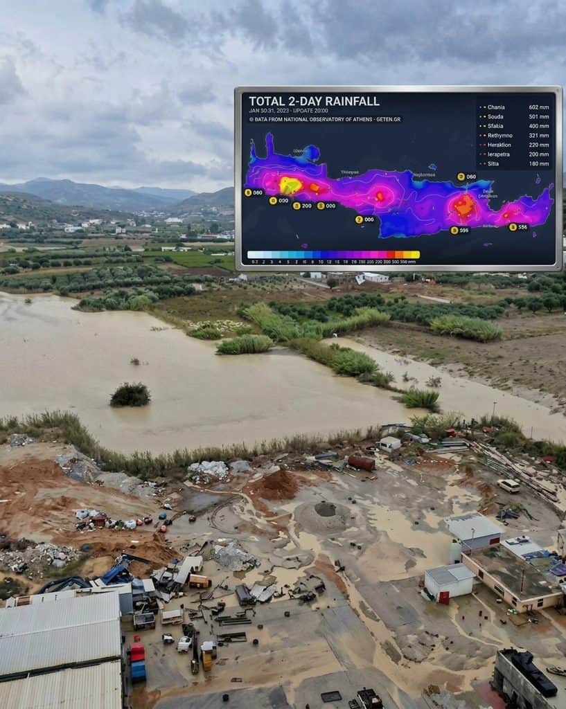
During this event, the strongest rainfall was concentrated particularly over the mountainous and northern parts of Crete, according to the National Observatory of Athens / meteo.gr.
The rainfall map released by meteo.gr showed the concentration of very high totals across these areas.
And Xyloskalo stood out.
The weather station there became the reference point for the extraordinary rainfall totals being reported across Greece.
This Was Not Just a Heavy Shower
Crete has always experienced intense autumn storms.
October is the month when the island begins its transition from the long, dry summer into the wetter part of the year.
But this event was different in scale.
The National Observatory of Athens / meteo.gr had already warned on Friday that a new round of heavy rainfall was expected to affect Crete, with particularly intense conditions in mountainous, semi-mountainous and northern parts of the island.
The rainfall episode for Saturday was classified by the METEO unit’s Rainfall Potential Index as Category 4 — “Very Significant.”
That warning proved important.
The storm was not a surprise.
Forecasters had identified the potential for a major rainfall event before the most intense conditions arrived.
And as the hours passed, the island began to experience the consequences.
The Storm Has Affected Much of Crete
The problem has never been limited to one weather station.
Heavy rainfall and thunderstorms have affected large parts of Crete, with serious problems reported in Chania, Rethymno, Heraklion and Lasithi.
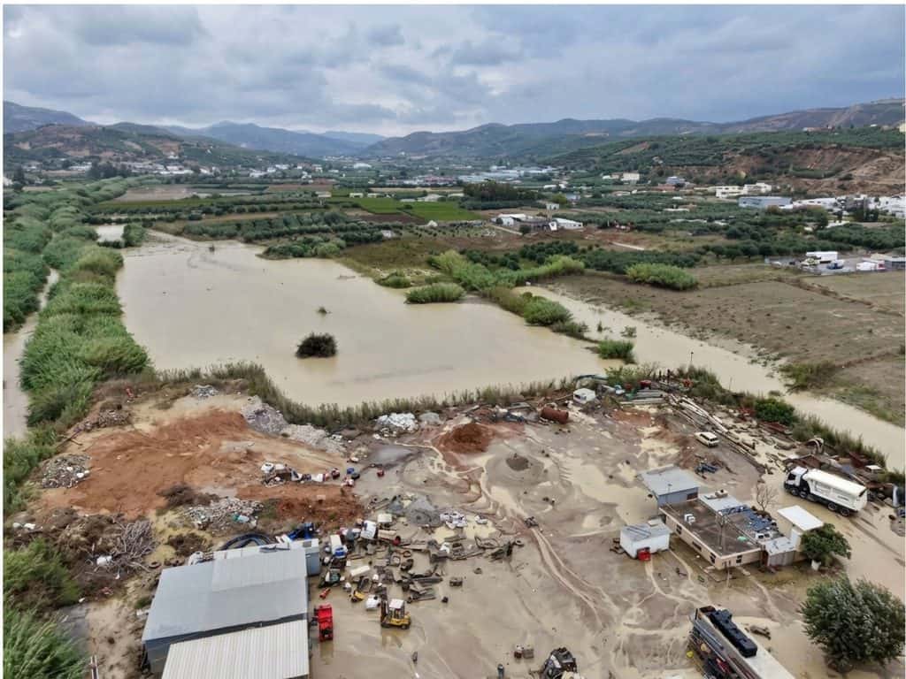
Floodwater and debris have affected roads, while some routes have been damaged or temporarily closed.
In the eastern part of the island, the road connecting Ierapetra and Sitia suffered particularly serious damage.
According to ERTnews, part of the road near Ferma was swept toward the sea, while 23 people who had become trapped in vehicles were rescued after mud and debris covered sections of the area. Eighteen of those rescued were Greek citizens and five were tourists.
The incident is a reminder that extreme rainfall in Crete is not simply a question of wet roads.
When mountain water moves rapidly downhill, it can carry enormous quantities of soil, rocks, branches and other debris with it.
A road that looks perfectly normal one moment can become impassable minutes later.
The Human Cost Has Also Been Serious
The weather emergency has caused more than infrastructure problems.
Greek authorities have reported a fatality in the Rethymno region, where an elderly livestock farmer died after being caught in floodwaters.
This is an important reminder that behind the dramatic rainfall statistics are real communities dealing with dangerous conditions.
Emergency services have been operating across the island, while residents and visitors have received repeated alerts through Greece’s 112 emergency notification system.
Authorities have urged people to limit unnecessary travel and follow instructions from local officials.
The situation has been serious enough for the entire island of Crete to remain under a Red Code mobilisation status through Sunday, October 4. The Ministry of Climate Crisis and Civil Protection said Saturday that strong rainfall and thunderstorms would continue, with the strongest conditions expected to gradually ease after Saturday but potentially continuing at lower intensity into Sunday morning.
Even the Samaria Gorge Has Been Affected
One of the most recognizable natural landmarks in western Crete has also been caught in the storm.
The Samaria Gorge, normally one of the island’s great hiking destinations, has been affected by the extreme weather.
ERTnews reported that eight workers inside the national park were unable to safely leave the gorge because of the dangerous conditions. They had entered the area for work several days earlier and were instructed to remain in a safe location while conditions prevented a safe evacuation.
For anyone familiar with the Samaria Gorge, the significance is obvious.
This is a spectacular but mountainous environment where heavy rainfall can transform a hiking trail into a dangerous watercourse.
The gorge is not a place where visitors should take chances during severe weather.
Why Does Crete Get So Much Rain in These Events?
Crete’s geography plays a major role.
The island stretches across the southern Aegean and contains several major mountain ranges.
The White Mountains, Psiloritis and the Dikti mountains rise dramatically from the surrounding landscape.
When unstable and moisture-rich air reaches the island, these mountains can enhance rainfall.
This is one reason why rainfall totals can be dramatically different between nearby locations.
A coastal town may receive heavy rain, while a mountainous station only a relatively short distance away can record several times as much.
The current event demonstrates this clearly.
The largest totals have been concentrated in mountainous and northern sections rather than being evenly distributed across the entire island.
And the Storm Wasn’t Finished Yet
Perhaps the most concerning part of Saturday’s situation was that authorities were not yet ready to declare the event over.
The Civil Protection Ministry said Saturday that strong rainfall and thunderstorms would continue in Crete through the day, with conditions gradually weakening but potentially continuing into Sunday morning. Crete was kept under Red Code mobilisation until Sunday, October 4.
Meteo.gr had also forecast another period of rainfall and thunderstorms into Sunday, although with a gradual reduction in intensity later in the day.
That matters because already-saturated ground cannot absorb additional rainfall as efficiently.
When the soil is saturated, more water runs across the surface.
That can increase the risk of:
- Flash flooding
- River and stream overflow
- Mudslides
- Rockfalls
- Landslides
- Road damage
- Debris flows
For communities in mountainous areas, the danger can therefore remain even after the heaviest rain has stopped.
The Numbers Tell a Bigger Story
The most remarkable thing about the Xyloskalo measurement is not simply that it passed 300, 400 or even 440 millimeters.
It is the concentration of that rainfall over such a short period.
The meteo.gr network recorded very high rainfall totals at multiple stations around Crete, with Xyloskalo among the highest.
To put the earlier 440 mm measurement into perspective, it represented approximately 440 liters of water for every square meter.
For an area of one hectare — 10,000 square meters — that would correspond to roughly 4.4 million liters of water, assuming uniform rainfall across the entire area.
That is an enormous volume.
Of course, rainfall is never distributed perfectly evenly across a landscape. A weather-station measurement represents the conditions at that particular location, not a claim that every square meter of the surrounding region received exactly the same amount.
But the calculation helps explain why the landscape has struggled to absorb and channel the water.
Why the Changing 440 mm Figure Matters
There is an interesting detail in the reporting of this storm that is worth explaining rather than hiding.
The first meteo.gr report published Saturday at 09:45 gave 440 mm at Xyloskalo.
A subsequent meteo.gr update at 10:45 reported 318 mm, based on measurements through 10:20.
Later on Saturday, the meteo.gr website displayed another update referring to 420 mm at Xyloskalo as the rainfall event continued.
This is precisely why serious weather reporting should always include the time of the measurement.
Rainfall totals during a live storm are not necessarily final.
Stations continue collecting data.
Maps are updated.
Measurements can be checked and corrected.
And the storm itself may continue adding more rainfall.
So rather than saying simply that “440 mm fell” and leaving it there, the more accurate description is:
More than 400 mm of rainfall was recorded at Xyloskalo during the event, with meteo.gr’s reported total changing as new measurements and updates became available.
That is both more precise and more useful to readers.
Crete’s Autumn Has Arrived With a Warning
For visitors who know Crete primarily as a summer destination, this storm is also a reminder of something important.
Crete is not only beaches and sunshine.
The island has a dramatic climate.
Summer can be extraordinarily dry, while autumn and winter can bring powerful storms and very heavy rainfall, particularly in the mountains and western parts of the island.
October is often a beautiful month to visit Crete.
The sea remains relatively warm, temperatures are generally pleasant and the summer crowds begin to disappear.
But October also marks a transition in the weather.
This year’s transition has arrived with exceptional force.
What Should Residents and Visitors Do?
The advice from authorities is straightforward: take the warnings seriously.
If you are currently in Crete, avoid unnecessary travel during periods of intense rainfall.
Do not attempt to cross a flooded road.
Do not walk through fast-moving water.
Do not park beside streams or in areas prone to flooding.
And if an official 112 message instructs you to move to higher ground or restrict travel, follow it.
This is particularly important for visitors who may not know the local geography.
A road that looks like an ordinary rural route on a map may cross a stream that can become dangerous within minutes.
Likewise, mountain hiking routes can become hazardous very quickly during thunderstorms.
The safest decision is often the simplest one:
Stay somewhere safe and wait for the storm to pass.
A Different Side of Beautiful Crete
There is something humbling about watching nature change the landscape so quickly.
The same mountains that attract visitors for their spectacular views can concentrate rainfall.
The same streams that are quiet for most of the year can become powerful torrents.
The same roads used every day can suddenly be covered by mud and debris.
And the same island that can feel almost impossibly dry in August can receive hundreds of liters of rain per square meter only weeks later.
That contrast is part of Crete.
It is an island of extremes — extraordinary sunlight, rugged mountains, deep gorges, powerful seas and, occasionally, extraordinary storms.
This weekend, the rain has reminded everyone of the power of the island’s landscape.
At Xyloskalo, the weather station has recorded more than 400 mm of rainfall during the event, with the exact reported total changing as the storm continued and the data were updated.
But the most important number is not the one on the weather map.
It is the number of people who get home safely.
Crete will recover.
The roads will be repaired.
The mud will eventually be cleared.
The mountains will turn green again.
And the sun will return.
For now, though, Crete is being reminded — once again — that beautiful nature deserves respect.
Stay safe, Crete. 🇬🇷
About The Author
